Lantana

#GPS

Hiking around the Chinyero

Chinyero is the name of a volcano in the National Park of Tenerife. Its last eruption was in November 1909, which was also the last eruption of a volcano on Tenerife.

The starting point is a tiny parking spot at the TF-38 that leads from the town Chío to the Teide national park. From there, we just follow the Circular Chinyero route, which is also marked with white and yellow posts. Our hike trip starts in a pine forest, then goes across a plain of volcanic rock, and then returns through a mix of pine forests and volcanic land.

Usually this place is located above the clouds. This time the clouds were rather high, and covered the landscape in a thick fog. It was very spectacular. At the plain of volcanic rock, it felt like we were walking on a foreign planet.

The tour is about 6.5 km long and easy to walk.

Continue reading...
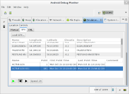
How to feed DDMS with gpsbabel

The Android Device Monitor is not just an aid for debugging applications, but also allows to simulate GPS positions, so you won’t need to actually run around in the countryside for testing your GPS app. But where to get test data from?

I have recorded some of my hiking trips with my Garmin GPS 60, and saved them in Garmin’s proprietary gdb file format. These files contain waypoints, routes and also recorded tracks.

The Swiss Army Knife for GPS files, gpsbabel, comes in handy for converting a gdb file into the GPX file format that can be read by DDMS. This is the line I used for conversion:

gpsbabel -i gdb -f hike-track.gdb -o gpx,gpxver=1.1 -F hike-track.gpx

Note the gpxver=1.1 option, as DDMS is unable to read GPX 1.0 files.

After converting and loading the GPX file into DDMS, I can now send single waypoints as GPS events to the emulated device. But beyond that, I can also play back a recorded track, and simulate that I carry around the emulated device on that track. This is very useful for testing GPS apps.